What a viral drone tour in a Rio de Janeiro hillside community can teach us about AI-powered operations
200 tourists stranded on a mountaintop during a police shootout in Rio de Janeiro. Dois Irmãos ("Two Brothers") is a twin-peaked mountain in Rio de Janeiro's South Zone. The only hiking trail to its summit passes through a densely populated hillside community called Vidigal. This morning, roughly 200 tourists who had hiked up before dawn to watch the sunrise became trapped at the top when a police operation in the community below turned into a firefight. There was no warning system, no way to alert hikers already on the trail, and no alternate exit route. They sheltered on the summit for over an hour before armored vehicles escorted them down. No one was injured — by luck, not by design. Drone-based tourism operations had recently expanded into this same community. This incident is exactly the kind of real-time coordination failure that Action AI's stack is designed to prevent.
See it for yourself
The drone tours that started a global trend
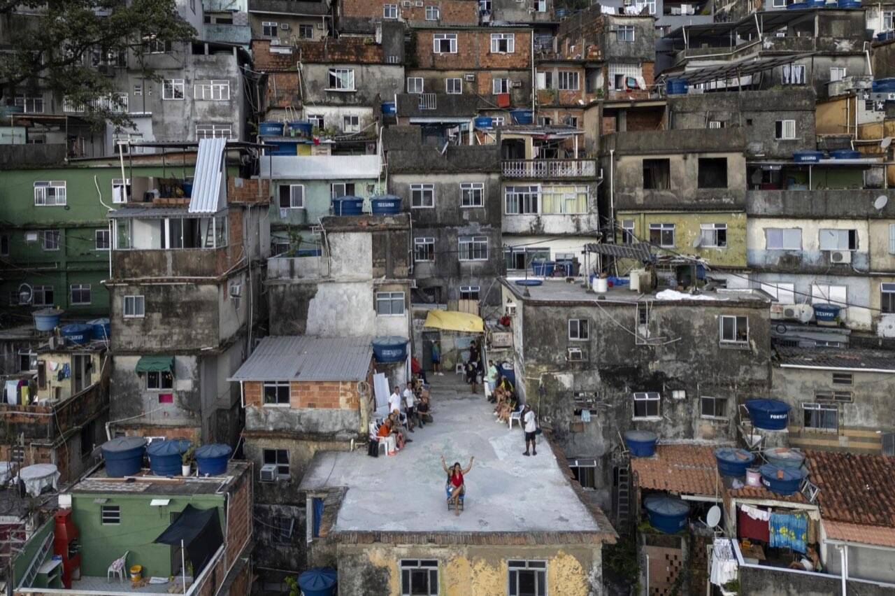
AFP coverage of the viral drone tours in Rio's hillside communities — 41,000 visitors in February 2026 alone. Source: AFP / France24
Tourists stranded during police operation — April 20, 2026
Approximately 200 tourists trapped on the Dois Irmãos summit while a police operation unfolded in the community below. April 20, 2026.
The scene
You climb to a rooftop in one of Rio de Janeiro's hillside communities — a densely packed neighborhood carved into the mountainside above the city's glamorous South Zone — and you wait. Sometimes twenty minutes. Sometimes two hours. Around you, tourists from six countries are doing the same thing, sweating in the subtropical heat, phones already out.
Then the drone lifts off.
It rises slowly, pulling back from the rooftop, and as it ascends, the full scale of what you're standing in reveals itself: kilometers of densely packed architecture, vivid and vertical, spilling down the hillside toward the glittering Atlantic. The glamour of Ipanema and São Conrado below. The favela above. The contrast is breathtaking — and for the past several months, it has been absolutely everywhere.
The trend has now spread to Portugal, inspired police departments, gone viral on TikTok and Instagram, and put a small Brazilian community tourism company on the global map. In February 2026 alone, the operation recorded 41,000 visitors across two neighboring communities.
The numbers behind the operation
The founder built this company for one reason: to show tourists the positive side of the community. That's not a tagline — it's the founding principle. The company was years in the making before the drone footage exploded globally.
To handle its current volume, the operation has trained 300 local guides and 10 drone pilots. Each visitor pays at least 150 reais — roughly $30 — and can only access the drone experience as part of a complete tour package. That means every visitor is routed through a maze of narrow alleys, stopping at local artists' studios, watching capoeira performances, engaging with the actual texture of community life before they ever reach the rooftop.
This is not a commodity tour. This is a structured, community-anchored experience operating at massive scale inside a residential neighborhood. 41,000 visitors a month in a place where the streets are three feet wide.
April 20, 2026: The incident
The drone tour operation recently expanded to a second hillside community — the same neighborhood where today's incident occurred. Dois Irmãos ("Two Brothers") is a twin-peaked mountain that sits between this community and the Atlantic coastline. It's one of Rio's most popular sunrise hikes. The only trail to the summit passes directly through the residential neighborhood below. There is no alternate route.
Here is what happened this morning:
-
~5:00 AM ~200 tourists begin hiking Dois Irmãos
Via the community trail to watch the sunrise. Standard morning activity — no alerts, no warnings in circulation.
-
~6:15 AM Police operation begins in the community below
A joint law enforcement operation targeting a fugitive hiding in a rented property in the neighborhood triggers a firefight. The community's single main road becomes a conflict zone.
-
~6:20 AM Tourists are trapped on the summit
The only descent route passes through the community. Gunfire below. ~200 people stranded on the summit with no coordination, no communication channel, no way to know what's happening, and no way to know when it's safe to move.
-
~6:45 AM Main coastal road closed
The primary road connecting the community to the rest of the city is shut down. Even if tourists could descend, ground transportation routes are blocked.
-
~7:20 AM Tourists escorted down
After the situation stabilizes, armored police vehicles escort tourists through the community. No injuries reported — by luck, not by design.
"With 41,000 visitors moving through a complex urban environment, the ability to locate groups, communicate real-time alerts, and manage incidents is not optional infrastructure. It is a liability question."
— Action AI case assessment
This morning's incident crystallizes every operational risk this case study describes. Two hundred people on a mountaintop, no real-time alert system, no multilingual communication channel, no way to redirect groups before they entered the danger zone. The only reason nobody was hurt is luck — not infrastructure.
And it's not just tourist safety. This is a residential community. 41,000 visitors a month flowing through streets where families live, children walk to school, and small businesses operate. When an incident like this occurs, the entire community absorbs the disruption. Responsible tourism at this scale requires coordination infrastructure that protects both visitors and residents.
The operational challenge
Let's be specific about what "41,000 visitors per month" across two hillside communities actually requires — and what breaks when you don't have infrastructure.
Two-hour waits in the heat
300 guides, 10 pilots, finite capacity. Without dynamic scheduling, visitors wait up to two hours in subtropical heat. Those waits create negative experiences, bad reviews, and crowding in residential streets. Tourists waiting have nothing to do and nowhere to go — unless the system reroutes them to local businesses, artists, or experiences while their slot opens up.
Weather grounds everything
Drone operations are 100% weather-dependent. Rio's sudden chuva — hard, fast tropical rain — can ground flights with zero warning. Without live pilot weather reporting and dynamic rescheduling, every rain event becomes a cascade: grounded drones, backed-up queues, frustrated tourists, and guides scrambling to reschedule on WhatsApp. Real-time weather data from pilots in the air would allow the system to proactively adjust slots, notify affected groups, and reduce downtime.
Six languages, one safety briefing
Visitors arrive from Brazil, the US, Europe, East Asia, and across Latin America. Safety briefings, community guidelines, tour instructions, and real-time incident alerts all need to work across at minimum five or six languages simultaneously — and they need to work fast when conditions change.
41,000 people in a residential neighborhood
These are living communities, not theme parks. Families live here. Children walk to school here. There are boundaries — physical, social, and organizational — that govern where tourist groups can go and when. When 41,000 visitors flow through streets that are three feet wide, the impact on residents is real. Coordination isn't just an operational need — it's a community responsibility.
Safety when things go wrong
Today's incident proves this is not theoretical. The ability to locate groups, communicate real-time alerts in multiple languages, trigger evacuation routes, and coordinate with law enforcement requires infrastructure that does not exist yet. There is no backup plan when the only exit passes through an active police operation.
Revenue at scale with no system
$1.2M/month across 300 guides, multiple currencies, cash and digital payments. Managing that cash flow, documenting it for compliance, and attributing it accurately requires financial infrastructure most tourism operators were never built for — especially when the operation scaled 10x in six months.
Right now, most of this is running on WhatsApp groups, manual scheduling, and the institutional knowledge of people who've been doing this since before it went viral. That is not sustainable at 41,000 visitors a month. And it will not survive the next incident.
What Action AI's Action Cell would do
The temptation when talking about AI is to wave hands and say "AI could fix this." That's not useful. What's useful is mapping specific operational problems to specific capabilities.
Live pilot weather reporting & dynamic scheduling
Drone pilots report real-time conditions from the air — wind speed, visibility, approaching rain. That data feeds directly into the booking system. When weather threatens, the system proactively adjusts: reschedules affected slots, notifies waiting groups in their language, and reroutes tourists to partner businesses — local restaurants, art studios, capoeira demonstrations — so the wait becomes an experience instead of a frustration. Downtime drops. Negative reviews drop. Local businesses earn revenue from the overflow.
Smart queue management & local business rerouting
Instead of 200 tourists standing in a narrow street for two hours, the system distributes wait time across the community. Visitors are routed to partner experiences — a coffee shop, a local artist's studio, a viewpoint — and notified when their drone slot opens. The queue becomes invisible. Tourists wait less, spend more at local businesses, and the physical crowding in residential areas drops dramatically. The community benefits instead of absorbing the burden.
Multilingual briefing & communication agents
Before a tourist group arrives, an agent sends them a briefing in their language — what to expect, community guidelines, safety protocols. During the tour, if conditions change, the agent communicates updates to the guide and the group simultaneously, in the right language. This isn't translation software. This is a coordinated communication workflow triggered by the conditions of the day.
Real-time safety & incident coordination
This is what would have changed today's outcome. If the Action Cell had been active this morning, here's what happens differently: the system monitors local security signals and community alert channels. When the police operation begins, an alert triggers immediately. Every guide with a group on or near the mountain receives a multilingual notification. Groups not yet on the trail are rerouted or held at safe locations. Groups already on the summit receive shelter-in-place instructions in their language with real-time status updates. The Command Tower coordinates with tour operators, law enforcement liaison, and transport providers simultaneously. Nobody is stranded on a mountaintop wondering what's happening below.
Command Tower — operational nerve center
A supervisor agent that monitors the entire operation in real time and flags anomalies before they become incidents. If a guide group hasn't checked in at expected waypoints, the Tower flags it. If drone operations are running behind and the next three booked groups haven't been notified, the Tower flags it. If weather data suggests rain in 90 minutes and four groups are still en route, the Tower flags it — and routes the alert to the human coordinator who makes the call. The humans stay in charge. The Tower makes sure they have the information they need, when they need it, before the window closes.
Policy governance
Rocinha and Vidigal have community agreements, safety protocols, and cultural boundaries that govern how tours run. Those policies can be fed directly into the agent system — not as brittle if-then rules, but as living documents that agents interpret contextually. When a new community restriction applies to a particular neighborhood, a guide updates the policy document. The agents adapt. No one rewrites the software.
Data quality & synchronization layer
Booking data, guide assignments, revenue data, community access data — almost certainly in separate systems or no system at all. A data governance layer ensures they talk to each other. When a booking changes, the guide assignment updates. When a route is restricted, affected groups are rerouted. No one manually reconciles four spreadsheets at the end of the day.
Projected impact
Conservatively
Perceived wait times cut in half — not by moving faster, but by rerouting visitors to local businesses, art studios, and cultural experiences while their slot opens. Weather downtime reduced by 40% through live pilot reporting and proactive rescheduling. Safety incident response cut from over an hour (today's reality) to under two minutes.
Less conservatively
The ability to scale from 41,000 to 100,000+ monthly visitors without a linear increase in coordination overhead. The ability to open new routes, new communities, new tour products — because the infrastructure can absorb the complexity. Local businesses earn revenue from the overflow instead of just absorbing the foot traffic.
And the community layer matters most of all
When the operation runs cleanly — when tourists arrive prepared, when guides aren't overwhelmed, when groups don't stack up in residents' doorways because the routing agent distributed them correctly — residents aren't burdened by the operation. They benefit from it. The streets stay passable. The businesses earn from the traffic. The safety protocols protect everyone — visitors and families alike. That's the foundation this operation was built on. Protecting it at scale requires infrastructure that doesn't exist yet.
The bigger point
"The guides should be guiding. The pilots should be flying. The founder should be building. The coordination infrastructure should be handled by systems built for that purpose. That is what AI is actually for."
The conversation about AI in business too often centers on automation as displacement. What we're describing here is something different: AI as the operational backbone that lets human-driven enterprises scale without losing what makes them human.
This operation works because it's built on real community relationships, real local expertise, and a genuine commitment to dignity. None of that is replaceable. None of it should be replaced. What should be replaced is the part where the team is manually reconciling bookings on WhatsApp while 41,000 people a month are trusting them with their safety and their experience of one of the most extraordinary communities on the planet.
After today, this isn't theoretical
Today's incident turned this case study from a projection into a documented need. Two hundred tourists on a mountaintop. No alert system. No coordination channel. No way to know what was happening below them. The drone tours have expanded to a second community. The operational risks have expanded with them. And the community — the families, the small businesses, the residents who share these streets with 41,000 visitors a month — deserves infrastructure that protects them too.
The technology exists. The methodology exists. The question is whether there's a governance architecture in place to make it work safely and measurably. That's what Action AI builds.
Who else has an operation like this?
If you run a community-based operation, a tourism business, a nonprofit delivering services at scale, a small clinic, a logistics operation, a staffing company — and your coordination infrastructure is a combination of WhatsApp groups, tribal knowledge, and heroic manual effort — this case study is about you.
The technology exists. The methodology exists. The question is whether you have the governance architecture to make it work safely and measurably.
We start with the baseline. We build from there.
Action AI builds AI operations infrastructure for solopreneurs and small-to-medium businesses. We accelerate your team — we don't automate them away.